The Indonesian Forest Where Tiger Density May Be Up to Four Times Higher Than in the National Park

Gunung National Park, Indonesia.

Gunung National Park, Indonesia.

For two decades, conservationists trained their cameras on Sumatra's flagship national park, believing the land mass’ last tigers survived only within fortified boundaries. Then, footprints appeared elsewhere.

Tiger tracks pressed deep into the mud of river corridors that provided them no legal protection and in the shadows of coffee plantations where maps showed agricultural buffer zones. Early data from these "forgotten" landscapes suggested something field teams didn’t expect: tiger densities potentially several times higher than those in the park. This isn't a story about Gunung Leuser National Park, but about the landscape scientists overlooked and how accessing it requires navigating alliances instead of trails.

Extraordinary exploration requires the kind of long-standing relationships with local cooperatives and conservation researchers that Zicasso's Indonesia specialists have developed over years, partnerships that can only be earned. As you consider Sumatra through a conservation lens, use the following to understand this emerging landscape before connecting with our travel experts to plan your journey.

Coffee Canopy vs. Palm Oil Monoculture: A Tale of Two Land Uses

Gayo Highlands, Indonesia.

Understanding why researchers found unexpected tiger populations in buffer zones requires consideration of the systematic elimination of fauna around those zones, a practice that made the animals’ survival improbable.

The lowlands smell like money and absence. Below 2,000 feet, where the Leuser Ecosystem's forests once cascaded from highland ridges to coastal wetlands, the air carries sickly industrial sweetness: clarified fat, diesel fumes, chemical fertilizers mixed with mud. The first sound you’d register is… nothing. No siamang whoops threading through the canopy. No hornbill calls. Just geometric rows of oil palms extending to the horizon, monoculture so sterile you can count biodiverse species in single digits. An intact forest would hold thousands. It’s green desert posing as canopy.

The Singkil-Bengkung corridor once connected the southern Gayo Highlands to coastal mangrove forests, but was severed between 1998 and 2007; that’s about 56 miles of lowland forest replaced with plantation blocks traceable on Indonesian land registry maps. The tigers that moved freely through that corridor are functionally extinct. Satellite imagery shows unbroken green at ground level that reveals itself as industrial agriculture: single-canopy height, wildlife value approaching zero.

What makes the Gayo Highlands critical isn't just that they maintain forest-compatible agriculture; it's their position between decimated lowlands and protected areas requiring connectivity to remain viable. When palm oil severed the Singkil-Bengkung and Tripa corridors in the 1990s and 2000s, highland coffee landscapes became the last remaining connection between fragmented forest blocks. The choice in Gayo was architectural: maintain the shade mosaic or complete the isolation demographic models predict will collapse northern Leuser's megafauna populations within three generations.

The Discovery That Rewrote Sumatran Tiger Conservation

Gunung Leuser National Park, Indonesia.

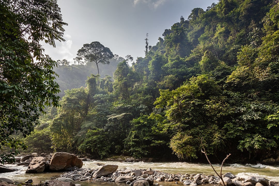
At 4,600 feet in the Gayo Highlands, the air carries competing signals: coffee cherries fermenting in village processing tanks, the darker humus of primary forest, where decomposition happens in geological time, and underneath both, musk. Not omnipresent, but there, a territorial marker of a large carnivore moving through shade canopy that field manuals said shouldn't support apex predators at a viable density.

Researchers affiliated with Leuser corridor restoration projects began expanding camera-trap grids beyond national park boundaries in early 2023, working with Indonesia's Forum Konservasi Leuser on what documentation termed "elephant migration route restoration." Tigers were expected beneficiaries. Not the headline. Then the tracks started appearing with frequencies that didn't match any model. Fresh pugmarks in stream sediment. Claw marks on drainage trees at territory boundaries. Scat deposits that genetic analysis revealed belonged not to transient sub-adults, but resident animals whose home ranges overlapped farmland, forest edge, and Gunung Leuser National Park's deep primary growth. The buffer zone wasn't buffering anything.

What the Data Revealed

In March 2023, a field team pulled SD cards from camera stations along the restored Wih Pesam river corridor and found what monitoring briefs carefully termed "unexpected tiger track records in newly reforested zones." Station WP-07, positioned where replanted riparian buffer met shade coffee at 3,870 feet, captured the same adult female returning to scent-mark a drainage tree over 17 nights. A station one mile upstream documented a different individual using the same game trail on alternating evenings for three weeks. These were territorial patrols.

The methodology matters for understanding what "up to four times more tigers" means in field communications. These aren't census counts from mark-recapture studies published in Conservation Biology. They're occupancy estimates and track frequency from community patrols compared against studies conducted inside Gunung Leuser National Park between 2008 and 2015. The ratio isn't peer-reviewed and mechanisms could involve corridor concentration, higher density or both. But observations are concrete: more tiger sign per kilometer walked, more camera triggers per trap, more scat yielding viable genetic material than anyone predicted.

What surprised field teams was evidence of territorial residency in landscapes people walk through to reach coffee plots every morning. The assumption was always that corridor colonization led back into protected areas, not permanent settlement in the corridors. The Gayo data inverts that logic.

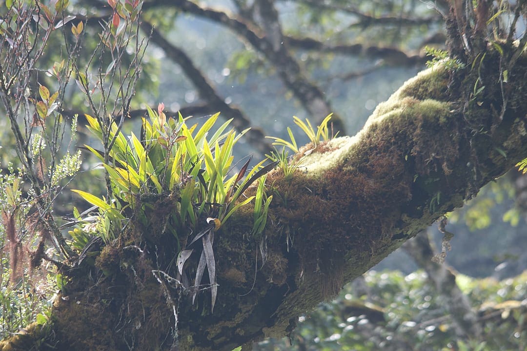
The ecological mechanisms challenge assumptions about optimal habitat. Core primary forest inside Gunung Leuser National Park offers an intact,120-plus-foot canopy, minimal disturbance, and established prey populations. But it also presents constraints buffer zones don't carry. Prey animals are two to three times more numerous than in the deep interior forest. Wild boar thrive where forest mast production meets agricultural spillover. Sambar deer graze where sunlight penetrates to ground level, stimulating browsing growth that closed-canopy forest suppresses. Tigers are pragmatic predators. If prey concentrates at edges and human tolerance permits safe passage, corridors become hunting grounds worth defending.

But there's a second factor: territoriality constraints inside protected areas. Gunung Leuser National Park holds established tiger territories whose residents exclude newcomers. A dispersing sub-adult might find every viable territory occupied. The buffer zone offers newly restored habitat with lower resident density, not because it's marginal, but because restoration only recently made it viable. Analysis from scat samples indicates female tigers establishing territories in buffer areas, requiring stable prey populations and successful reproduction, conditions beyond corridor use into true habitat function.

Why "Unprotected" Forests Became the Tiger's Real Stronghold

When Bukit Barisan Selatan National Park documented extensive illegal coffee cultivation inside protected boundaries in 2006, it found legal designation without economic alignment produces catastrophic failure. Low coffee prices and weak governance created incentives to clear protected forest that official park status, despite ranger patrols and legal penalties, couldn't prevent. Legal protection revealed itself as bureaucratic and easily punctured.

The Gayo buffer zone represents inverse architecture. Coffee economics are specific enough to trace on spreadsheets. Farmers participating in sustainability programs receive approximately fifty cents per 2.2 pounds premium above market price for coffee verified as forest-compatible. A similar amount flows to conservation programs. For a smallholder producing 3,300 pounds of green coffee annually, a typical harvest from under five acres, that premium represents $750, roughly 20 to 25% of total coffee income. That premium evaporates if forest cover drops below program thresholds or monitoring detects encroachment into riparian buffers.

This creates enforcement that park boundaries lack. "Unprotected" means no boundary to enforce, but also no boundary to resist. Community rangers who monitor for signs of tigers aren't external enforcers, they're farmers whose coffee premiums depend on maintaining the forest cover. Protection through overlapping incentives functions with granite permanence, while brittle and remote policy enforcement repeatedly fails. Tigers benefit because the forest structure required for premium coffee, that of shade canopy, undergrowth complexity, and riparian corridors, is required for viable carnivore populations.

The Four-Species Coexistence: Why This Ecosystem is Globally Unique

Sumatran Tiger, Indonesia.

The road from Takengon climbs through coffee terraces following volcanic contours like physical elevation lines, each band carrying a different microclimate, processing cooperative, and shade-tree density. At 2,950 feet you're still in the transition zone where lowland heat meets highland cool. By 3,940 feet, the air gains weight with moisture that never quite becomes rain and sound carries farther than physics should permit. The call to prayer from a village mosque mixes with siamang territorial whoops, whose dawn chorus marks forest intact enough to still hold them.

The Leuser Ecosystem carries a designation that sounds like conservation marketing, until you understand what it means functionally: the last place on Earth where Sumatran tigers, orangutans, elephants, and Sumatran rhinos coexist in continuous landscape. Overlapping ranges where megafauna interactions that shaped these forests for millennia still occur, where ecological roles most tropical systems lost decades ago remain intact enough to measure.

The maintenance of trophic structures and ecological processes determines whether forests persist or begin slow collapse toward simplified ecosystems that can't recover from the disturbance. When you lose the big animals, you also lose the forest's integrity, its capacity to regenerate, and its resilience against climate disruption that already affects equatorial networks. The four-species coexistence is not a feature, but the ecological foundation.

The Only Place They All Survive Together

Habitat loss and poaching fragmented populations so severely that this four-way overlap exists exclusively in northern Leuser, where roughly 2.2-million acres of ranges intersect and all four species maintain breeding populations. Bukit Barisan Selatan lost rhinos. Way Kambas lost tiger populations. The combinations that should exist across Sumatra's mountain spine have reduced to a single landscape where protection and corridor connectivity have prevented terminal fragmentation.

These four megafauna species shape forest structure. Tigers, as apex predators, regulate ungulate populations, preventing overbrowsing that would shift forest composition toward browse-resistant species. Elephants, as megaherbivore, create canopy gaps through tree-felling, maintaining diverse plant communities and invertebrates and small vertebrates dependent on structural complexity. Orangutans, as large-bodied frugivore, disperse seeds for trees whose fruit size excludes smaller dispersers. This is irreplaceable in maintaining genetic connectivity in canopy-dominant trees.

The Gayo buffer zone goes beyond being a tiger habitat. It maintains four-species coexistence. If those corridors fail, northern Leuser populations will fragment into isolated units that will collapse within three to five generations, modeling predicts. That’s about 60 to 80 years for tigers and catastrophically faster for rhinos already at a genetic bottleneck threshold.

Pleistocene Functional Complexity: What That Actually Means

Ecologists use "Pleistocene functional complexity" to describe ecosystems retaining the full suite of trophic roles. Most tropical forests lost this complexity centuries ago. Leuser's combination creates cascading effects measurable in vegetation structure, seed dispersal networks, and nutrient cycling. Elephants fell trees, creating light gaps. Light gaps stimulate pioneer species growth. Pioneer species provide early-succession fruit for hornbills, macaques, and, eventually, orangutans, whose seed dispersal connects forest fragments. Tigers regulate wild boar populations. Boar root behavior affects soil turnover and seedling survival. The interactions spiral outward into networks ecologists term "ecological complexity."

Break the corridors and you don't just isolate tiger populations. You eliminate megaherbivore movement that creates canopy gaps, frugivore dispersal that maintains tree genetic diversity, and predator regulation that prevents ungulate overbrowsing. The system simplifies and simplified systems in equatorial forests don't recover, they degrade toward conditions where carbon storage drops, species richness collapses, and resilience evaporates.

The Future of the Buffer Zone: Conservation Through Commerce

Forest textures in the Gayo forest, Indonesia.

The Gayo buffer zone operates without illusions about permanence. The economic architecture aligning coffee premiums with forest protection functions because market conditions make it profitable, community governance makes it enforceable, and corridor restoration funding makes it scalable. All are variable. Coffee prices fluctuate. Community priorities shift. International conservation funding contracts when donor attention moves to newer crises. The question isn't whether this model works because field data confirms it does, but whether it's durable enough to outlast political and economic volatility that kills most conservation programs within a decade.

The architecture requires constant maintenance. Premium prices depend on certification systems requiring annual audits. Corridor restoration needs ongoing funding of roughly $800 to $1,200 per acre for initial replanting as of 2026. Then there are monitoring costs of $15,000 to $25,000 annually per major corridor. Community ranger programs cost $200 to $300 per ranger monthly and effective monitoring requires minimum 10-person teams per watershed. The UNDP Lion's Share mechanism funds much of this, but that mechanism expires in 2027 and renewal isn't guaranteed. If funding collapses, corridor monitoring stops, certification audits lapse, and economic incentive maintaining forest cover evaporates within a single harvest cycle.

High-value, low-impact tourism represents one potential revenue stream to reduce dependence on donor funding, but only if structured to channel significant per-visitor fees directly to corridor maintenance rather than leaking into national tourism infrastructure.

How Visitor Fees Fund Corridor Restoration

Corridor restoration in Leuser, which entails replanting degraded riparian strips, installing camera-trap grids, and funding community ranger patrols, depends on grants and international funding. The UNDP Lion's Share contributed $4.2 million between 2020 and 2024. Saving Nature's river corridor expansion raised $890,000. These are meaningful budgets, but they're project-specific and time-limited, creating funding gaps when projects end and new grants haven't been secured.

Conservation tourism offers different financing: high per-visitor fees channeled directly to corridor maintenance, creating quasi-permanent revenue streams that are not dependent on grant renewal cycles. Corridor monitoring for a single watershed costs approximately $20,000 to $30,000 annually. If 50 visitors pay $600 per person in buffer-zone access fees dedicated to conservation, that's $30,000, sufficient to fund one corridor year-round. Scale to 200 visitors across four corridors and you've generated $120,000 in stable funding independent of grants.

The model works elsewhere. Virunga National Park charges $400 per person for gorilla permits, with revenue funding ranger salaries and community programs. Namibia's conservancy tourism generates $6 to $7 million annually, funding anti-poaching and habitat restoration. The Gayo buffer zone could implement similar fee structures, with access costs reflecting conservation funding needs.

But implementation requires infrastructure that doesn’t exist at scale: formalized partnerships between community cooperatives and vetted tour operators, transparent revenue-sharing agreements, and monitoring systems to ensure fees reach intended programs. Formalizing that into systematic tourism revenue would require governance structures communities haven't yet built and might resist building if formalization threatens the autonomy that makes current systems work.

Access Reality

Accessing the Gayo buffer zone requires navigating governance structures tourism infrastructure hasn't formalized and possibly shouldn't. Communities managing these corridors make access decisions based on whether proposed visits align with conservation priorities, respect customary land rights, and channel meaningful resources to corridor maintenance. This isn't bureaucratic permission, it's relational trust operators like Zicasso's Indonesia specialists build through years of commitment to community priorities and conservation funding.

This means you can't book buffer-zone tiger tracking through conventional tourism channels. Cooperatives controlling access don't advertise, maintain websites listing services, or respond to inquiries from travelers who haven't been vetted by research partners or conservation organizations they trust. Access emerges from existing relationships extended to visitors demonstrating serious conservation interest, willingness to contribute meaningfully to corridor funding, and respect for working landscapes where coffee production and community safety take precedence over tourist experience.

Vetting Legitimate Access

Revenue structures distinguish legitimate access from exploitative tourism. Legitimate operators channel significant per-person fees directly to community conservation funds, ranger salaries, and corridor monitoring, with transparent documentation communities can verify. Exploitative operators pay village "access fees" to individuals without community authorization, extract experience value without funding conservation, and often violate protocols regarding group size, timing, and noise discipline residents have established to minimize disturbance.

If an operator claims buffer-zone access, but can't name cooperative partnerships or explain how fees reach conservation programs, that access is likely unauthorized or minimally coordinated. Legitimate access involves documented agreements with communities managing the Wih Pesam watershed or Burni Telong corridor zones.

Best Seasons for Tiger Sign Detection

Tropical rainfall patterns influence track visibility, river levels, and trail conditions, determining whether monitoring transects yield useful data or just muddy miles with ambiguous sign. The drier period from June through September offers clearer footprints and safer river approaches, as stream sediment firms up enough to hold distinct pugmark impressions and lower water levels expose sandbars where tigers move between forest blocks.

The animals use river corridors year-round, but the wet season from October through March brings flooding, forcing them to higher ground where tracks disappear in leaf litter and rocky substrates. Community rangers continue patrols, but track detection rates drop significantly. For visitors whose experience centers on observing and interpreting sign, dry-season timing is nearly mandatory.

But "dry season" in equatorial montane forest doesn't mean California summer. It means reduced rainfall from 12 inches monthly to six inches, with substantial moisture, afternoon rain, and mud. The temperature varies with elevation more than season. At 4,600 feet, expect daytime temperatures of 64 to 75°F, dropping to 54 to 59°F at night. Higher elevation corridors toward Burni Telong (5,900-plus feet) are cooler. Layer appropriately and expect to be damp most of the time, whether from rain, stream crossings, or sweat.

Start Your Sumatra Tiger Experience

Suman Tiger, Indonesia.

The Gayo buffer zone represents conservation architecture that functions precisely because it hasn't scaled into conventional tourism infrastructure, and scaling without destroying what makes it work requires bucking the online mass-tourism trend. If you’re interested in learning more about conservation for the Sumatra tiger, this article cites information from the original research paper: Sumatran tiger density estimates in the Leuser Ecosystem, Sumatra, Indonesia, in addition to Selfies of Endangered Sumatran Tigers Expose a Robust Population.

Zicasso's Indonesia destination specialists maintain connections with researchers and community organizations who can facilitate corridor access when timing works for you. If you're ready to engage with conservation on those terms, connect with our specialists to explore whether this experience aligns with your travel orientation and timing.

30,000+ Verified Traveler Reviews